2002 08 15 Alamosa CO to Rock Springs WY
Well, whatever else I will say, I have to say first this was a long day. I decided to leave the dunes this morning since I realized I want to spend as much time in Wyoming as I can. I am going to be flying back out of Denver on 8.22, and I will probably have to spend a night there and drive on Wednesday. Working backwards does not leave me with a huge amount of time..
So, I left early, after finally meeting the ranch manager at Medano-Zapata, and basically drive all day. If you look at a map of CO, UT, and WY you'll see I covered a lot of ground. Out to 17N from the dunes, to 285, the 24 through Leadville CO, then I70 west to Rifle, north on CO 13 to Meeker, then CO 64 west to Rangely and US 40 to Vernal UT, then US 191 north into Wyoming and the wonderful metropolis of Rock Springs. Once away from Rifle CO it is like being on another planet. Very remote again, with all sorts of weird and wonderful rocks.
(The ranch manager convinced me using maps and his knowledge of the west side of the dunes that I would really be no better off getting access that way. It would be just as easy to hike around from the east. I would also not have to deal with the 2200 bison that are running around over there. The ranch manager was concerned about that, and so would I be!)
I ran into two fires, one I could see plainly, and the other than merely filled the sky with smoke, reducing visibility to about 2 miles. I'll try to do this all in some sort of order though, since if I don't, and then I don't do this tomorrow, it won't get done.
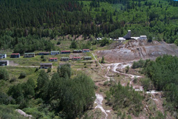
At first I thought I would just put a brick on the accelerator and drive, take no snaps, stop for no serious shooting, and just punch it on up here. That did not last very long. On 24 just south of Leadville there is this mine:
 |
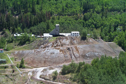 |
which as you can see has made quite a mess out of some very nice forest. I would have liked to got in there to photograph, but it was all locked down and posted. One of those places I could try to get permission into..
I stopped in Leadville, which used to be a mining town and is now more or less devoted to tourism. I think it is the highest city in the US, at a little over 10,000 feet. You can tell too. I felt like either my hat was shrinking, or my head was getting bigger, or perhaps I was feeling the altitude a little. The sun is very intense and the air very dry, too. Lots and lots of derelict mines all around. The town reminds me a little of Truckee. A place that used to be something else entirely.
While in Leadville I got to see four billion dollars fly over, in the form of 2 B2 bombers. They must have been up about 20,000 more feet, but I had binoculars and could see them very well. The fact that there were two planes flying the same course close together told me they were not civilian and might be interesting. As I understand it those two B2s represent 1/16 of the entire fleet. Perhaps they were off on a mission someplace. When B2s were used in Afghanistan the missions originated and ended at their "home base" in Missouri! They are too expensive and contain too many secrets to actually risk..
On the way down and out of the Rockies on I70 you go through the Glenwood Canyon, which is very cool. It looks more or less like this:
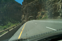 |
The canyon walls are right there and very high and steep. The Colorado River had clouds of kayakers in it and a few rafters. Note the bug collection on the windshield.
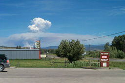
OK, here's that first fire. This was taken from Meeker, on Hwy 13. The fire is about 20 miles east and someone in the agency here told me it was "a lot more" than the 500 acres it started the day as.
 |
And here is an interesting thing. This is fiber optic cable being laid along CO 64 between Meeker and Rangely.
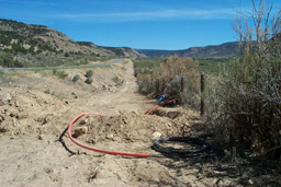 |
The conventional wisdom has it that all the telecoms blew up in large part because they borrowed trillions of dollars to lay billions of miles of fiber, and that enough is in the ground to last well into the next millenium. If that is true, who is putting this in the ground, and why out here in the literal middle of nowhere? As you can see this area is not exactly packed with Internet Cafes.
On into the NE corner of Utah. We're now getting into serious "drillin and diggin" country. This is a very large phospate mine, half owned by Mr. Potato himself, J.R. Simplot. Apparently when he wants to get his fertilizer wholesale he does not fool around:
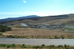 |
It's hard to convey the scale of this operation. A small part of it is in this snap. The dump trucks down there could, I think, hold any of our living spaces with very little if any disassembly required. They were lumbering up and down the mountainside raising huge dust clouds.
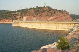
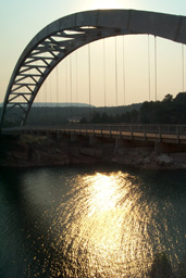
These next shots were taken at the Flaming Gorge Bridge and Dam. Flaming is right today. The sky is getting very smoky and the sun is very coppery due to smoke from a fire to the west on the UT/WY border. You could really smell it too. Visibility went down to about 2 miles, I think. There are also a couple of shots here of the dam which was built in 1969, damming the Green River.
 |
 |
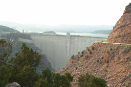 |
That is the front and back of the dam, and you can see how smoky it is.
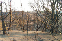
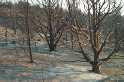
The last serious stop I made was to actually run some film. I drove through the remains of the "Mustang Creek" (?) fire which burned for about 2 weeks in June and July. It was immense, and in the coppery light all the scorched earth and burned trees looked very spooky. I got a lot of material here and I think some of it will be pretty interesting. I stayed until I ran out of light, chasing it up a burned hill, and then got back on 191 and headed north. Here are a couple of snaps:
 |
 |
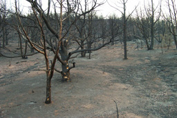 |
There were miles and miles of this, interspersed with the occasional hillside that was spared. Quite amazing. Of course I took off into this in my Tevas, not realizing that the ground that was not scorched rock was going to be 4 inches of very fine soot. Nice. Next time you clean your grill dump the ash on the ground and walk around in it..
Here is a good fire link:
http://www.nifc.gov/fireinfo/nfn.html
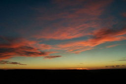
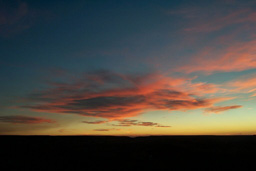
I'm still not a sunset sort of guy, but since the last one got a response I'll include this one from today. Shot along 191 about 30 miles south or Rock Springs Wyoming. This is along a very high ridge and looks like someplace I will want to go back to over the next few days.
 |
Here's another without that contrail.
 |
Speaking of contrails, did you know about this?
http://www.sciencenews.org/20020511/fob1.asp
And, here's a puzzle. If 90% of the water used in Colorado is used by agriculture, why would the state authorities be beating up the non-agricultural users of the remaining 10% in order to cut total use during this very serious drought? I mean, good problem solving tells us to go where we'll get the most savings for our efforts. If agriculture cuts their use by 1/9 (about 11%) that would have the same effect on overall water consumption as eliminating all non agricultural use completely! In other words, we could get all industry to move away, and get all those pesky voters and other non-farming types to move out of state, and thereby stop using any water, and still only get as much reduction as having farm use drop by that 1/9. Not that lawns are a good thing in the arid west, mind you, or car washes, or any of the other non farm wasters of water. But why not go after agriculture? I can't tell you how many center pivot irrigation systems I saw blasting a fine mist of water into the air in 90 degree heat.
Well, I am happy I got this done. I am not getting up early tomorrow.